Subscribe
HIKE LOS ANGELES
  • Home
  • Destinations
    • Griffith Park >
      • Mt. Hollywood
      • The Lonesome Pine
      • Bee Rock
      • Griffith Park Trail Run
      • Amir's Garden
      • Royce's Canyon
      • Hollywood Sign
      • Cahuenga Peak Hike
    • Santa Monica Mountains >
      • Escondido Canyon Hike
      • Inspiration Point Hike
      • Sandstone Peak Hike
      • The Grotto Hike
      • Calabasas Peak Hike
      • Paramount Ranch Hike
      • Fanklin Canyon Lake Loop Hike
    • San Gabriel Mtns./Angeles National Forest >
      • Sturtevant Falls Hike
      • Eaton Canyon Hike
      • Mt. Baldy Loop Hike
      • Echo Mountain Hike
      • Trail Canyon Waterfall Hike
      • Monrovia Canyon Waterfall Hike
      • San Gabriel Peak/Mt. Disappointment Hike
      • Mount Lowe Hike
      • Switzer Falls Hike
    • Verdugo Mountains >
      • Verdugo Peak
      • Mt. Thom Hike
      • Verdugo Sunset Hike
      • Cross of San Ysidro Sunrise Hike
    • Santa Susanna Mountains >
      • Oat Mountain Hike
      • Rocky Peak Hike
      • Don Mullally Trail Hike
      • Towsley View Loop Trail
  • Specialty Hikes
    • Sunrise/Sunset Hikes
    • Waterfall Hikes
    • Historic Hikes
    • Hollywood Sign
    • The 5 Peaks
  • Resources
  • Blog

MT. HOLLYWOOD HIKE
   
     DISTANCE:  6.2 miles Roundtrip
     ELEVATION: 1625'

     ELEVATION GAIN:  1125'
     TYPE: Out-and-Back
     HIKING TIME: 2.5 - 3 Hours
     
RATING:  Strenuous
     
FEATURES:
Vistas of Downtown LA, San Gabriel Mtns., 
                            Pacific Ocean, Catalina Island, Hollywood Sign,
                            bag multiple peaks on one trip

TRAIL HIGHLIGHTS


For most of the Griffith Park's History Mt. Hollywood has stood at the center as the tallest and most visited peak in the park.  With the addition of Mt. Lee and Cahuenga Peak in 2010, Mt. Hollywood fell to the third highest peak in the park, but the stream of visitors hasn't changed due to the relatively short hike on the Charlie Turner Trail from the Griffith Observatory.  However, the Charlie Turner Trail is a rather uneventful hike, more a thoroughfare to a destination than a journey to be undertaken.  The Hike-LosAngeles trek to Mt. Hollywood's summit is a more challenging and inspiring hike.  Beginning near the Pony Rides on Crystal Springs Drive, the trail passes Beacon Hill, Glendale Peak and climbs the spine of Hogback ridge with its sweeping vistas as the canyon walls fall away before delivering you to the top of the park's central peak.  The climb is steep, and in a few instances brutally so, but the views are all encompassing, from the San Gabriels in the east to the Pacific Ocean in the west.  So mingle with the mob on Charlie Turner or take the challenge of Hogback Ridge.  If you're a true hiker, we're guessing you'll choose the latter!
Click the full frame icon in the upper right corner for a larger map in a separate window.

Directions to Trailhead

Griffith Park
Crystal Springs Dr.
Los Angeles, CA 90027

Exit the 5 at Los Feliz Blvd and head west approximately .2 mile.  Turn right onto Crystal Springs Drive at the entrance to the park and proceed .4 mile.  Park along Crystal Springs Drive or in the Pony Ride Lot.

Trailhead is across Crystal Springs Drive on the dirt fire road next to the Marty Tregnan Golf Academy.

Mt. Hollywood Trail Guide
Click for printable .pdf trail guide and map.

Picture
Trailhead

        The trail  begins on the dirt fire road next to the Marty Tregnan Golf 
       Academy. The trail curves to the right and climbs .1 mile to a hairpin turn 
       to the left, continuing another .15 mile to the first trail junction.

Picture
 Trail Junction 1

         As you reach the junction the trail will level out briefly.  The trail forks with a 
        hairpin turn to your right and a second trail almost directly in front of you, 
        running parallel to a high chain link fence at the back of the golf academy 
        driving range.  Follow the trail along the fence.

        Once you have cleared the fence you will descend briefly into the next canyon
        and then begin a long, steady uphill climb until you reach the Klass Water Stop
        in just over a mile.

Picture
Trail Junction 2
   
        The trail forks again, but this time you will take the hairpin turn up and to your  
        right.  The trail will become quite steep for the next .3 mile.

        As you climb this section of the trail, you may notice a number of dead and 
        burnt trees.  This entire section of the park was devastated by fire in the spring
        of 2007 and the surrounding slopes where reduced to little more than ash.

Picture
Hiker's Rock

        At around .9 mile into your hike you will come upon a large rock that has fallen
        from the slopes above.  This rock has been perched on the edge of the trail 
        for years and has offered hikers a spot to rest and take in the view.  Following 
        the 2007 fire, as more dirt and rock eroded from the upper slopes, park crews 
        bulldozed the debris to the edge to maintain an open fire road.  In the process
        they completely covered the rock.  Hikers have, over the intervening years, 
        slowly scraped away the dirt to expose the rock once again.

Picture
Trail Junction 3 - 5 Points

        For the last .5 mile or so you've had a relatively easy climb.  The trail will 
        become moderately steeper at the 5 Points intersection, but it's only .2 mile to 
        the Klass Water Stop.

        5 Points is the intersection of 5 different trails.  The trail immediately to your 
        right is a short trail up to Beacon Hill (1001').  If you are a peak bagger, you 
        may want to make the short side trip to the summit for a nice view of Glendale 
        and Forest Lawn Cemetery.  The trail directly opposite you will take you down 
        to the Carousel and Shane's Inspiration section of the park.  The trail angling 
        off to your left skirts the Water Stop and comes out at the Heliport.  To your 
        immediate left is the trail to the Water Stop.  Make the hairpin turn to your left 
        and continue for .2 mile.

Picture
Beacon Hill, 1001'

       Access this summit with the eastern most trail at 5 Points.

Picture
Trail Junction 4 - Joe Klass Water Stop

        The Joe Klass Water Stop is a small picnic area with tables, water fountain and
        horse watering trough for equestrians.  A stainless steel bowl has also 
        been placed at the water fountain for your four-legged friends.

        When you leave the Water Stop, continue uphill on Vista del Valle Drive (a 
        paved road closed to vehicular traffic) for .3 mile past the heliport/scenic 
        overlook on your left to the next trail junction at the green maintenance shack.

Picture
Helipad

        Officially designated as a helipad, this scenic vantage point has spectacular 
        views of Los Feliz, Silverlake and downtown Los Angeles.  It is also a frequent
        filming spot for movies, television shows and commercials.

Picture
Trail Junction 5

        Turn left off the paved road onto the dirt fire road.  Two different fire roads 
        converge at this intersection.  Take the one on the right, going uphill past the 
        green maintenance shack and continue for approximately 1.0 mile.  This is the 
        Hogback Ridge Trail and will contain the steepest climbs of the hike and some
        of the best views.

Picture
Trail Junction 6

        Just under .4 mile from the last Trail Junction you will reach a footbridge.  
        Cross the footbridge and continue on Hogback Ridge Trail to reach Mt. 
        Hollywood.  The footbridge marks the beginning of the steepest portions of the
        trail and once you clear the small knoll just past the bridge, the views open up 
        dramatically on all sides as you make your way along the ridge.

        For peak baggers or those looking for an interesting side trail, Henry's Trail, 
        named for the late Henry Shamma of the Sierra Club, starts on the nearside of
        the footbridge and leads to Glendale Peak, 1184'.  This side trail is a more 
        secluded and easier climb than the upcoming portion of Hogback Ridge and 
        offers its own grand views with far fewer people.

Picture
Glendale Peak, 1184'
  
       Access this peak from Henry's Trail at the foot bridge.

Picture
Hogback Peak, 1480'

        This high promontory on Hogback Ridge is officially unnamed, but has been 
        given the name Hogback Peak by hiking enthusiast Dan Simpson. You can 
        check out some of Dan's hikes at www.simpsoncity.com/hiking.

Picture
Trail Junction 7

        Hogback Ridge officially ends at Dante's View and the intersecting Mt. 
        Hollywood Trail (aka Charlie Turner Trail) fire road coming in on your left.  At 
        this intersection you will find another water fountain and a watering bowl for 
        pets.  If you have time, take a few minutes to explore the garden's of Dante's 
        View.  It offers some of the only shade on the entire hike and has picnic tables 
        and walking trails.

        Completely destroyed by the 2007 fire, Dante's View has made a remarkable 
        comeback thanks to park staff and the many volunteers who care for the 
        gardens.  Dante's View was originally created and cared for by Dante Orgolini 
        in 1964.

        To make the final ascent to Mt. Hollywood, continue through this intersection 
        to the next trail junction less than .1 mile ahead.

Picture
Trail Junction 8

        At this junction make the hairpin turn to your left and continue past the picnic 
       area for a moderate .2 mile climb to the summit of Mt. Hollywood.

Picture
Mt. Hollywood, 1625'

       Congratulations!  You've reached the summit of the third highest peak in 
       Griffith Park.  From here you can see Downtown Los Angeles, Hollywood, the 
       San Gabriel Mountains, the Pacific Ocean and, on clear days, Catalina Island.

LIghtbox feature now active. Click on any trail photo for a larger version.
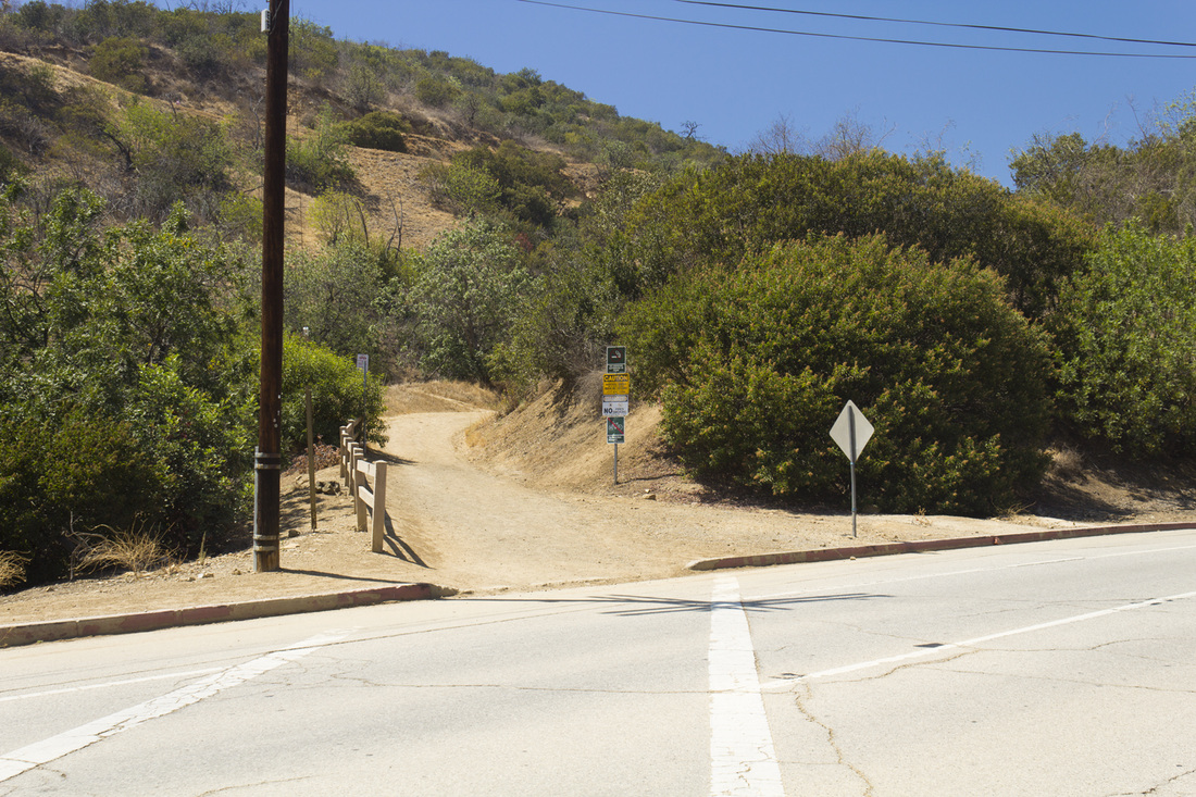
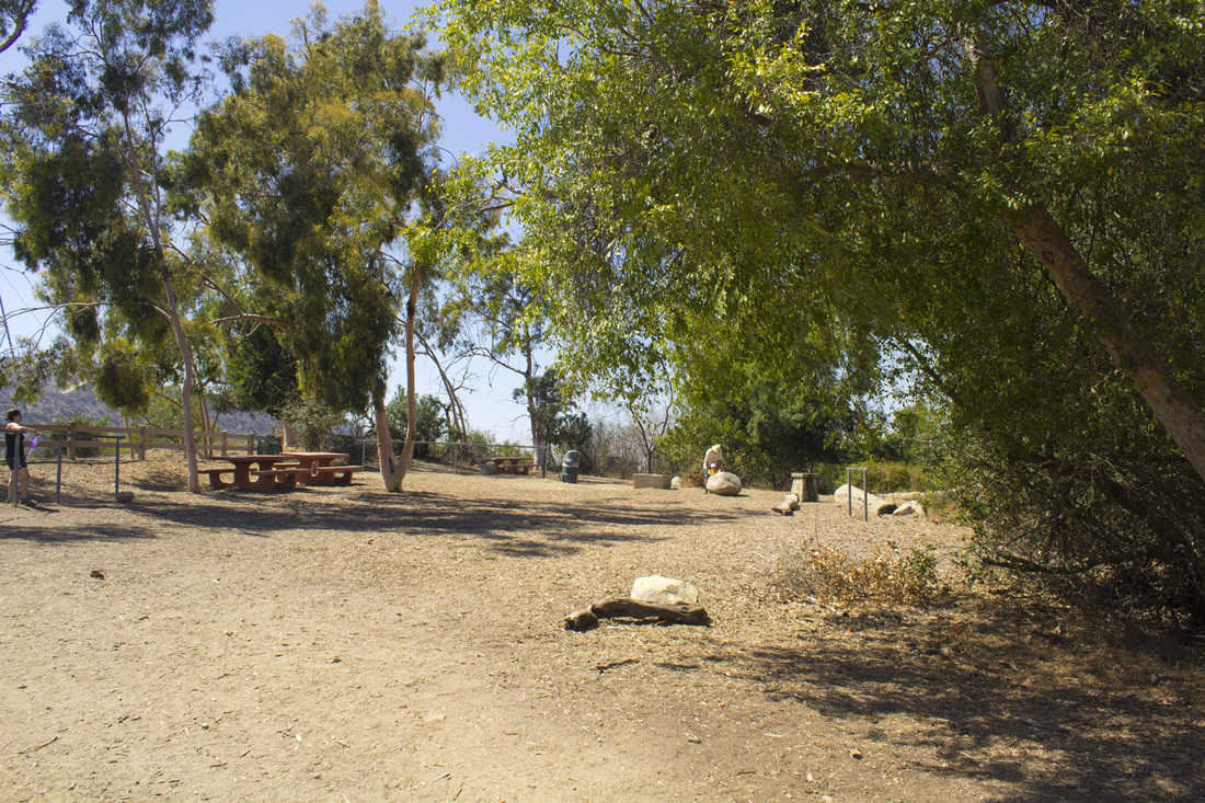
Mt. Hollywood Trailhead
Picture
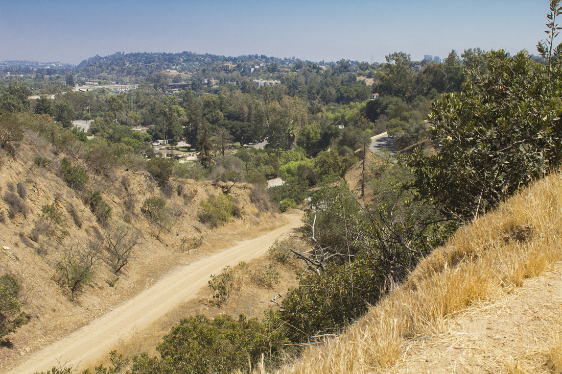
Trail below Junction 1
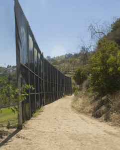
Picture
Trail Junction 1
Picture
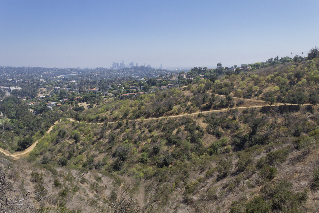
The Trail from Hiker's Rock
Picture
Trail Below 5 Points
Picture
Trail Junction 4 - Joe Klass Water Stop
Hogback Ridge Footbridge
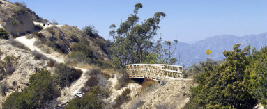
Footbridge at Hogback Ridge
Picture
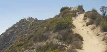
Trail to Hogback Peak
Picture
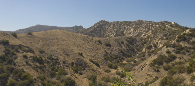
Mt. Hollywood and Hogback Ridge
Powered by Create your own unique website with customizable templates.