Subscribe
HIKE LOS ANGELES
  • Home
  • Destinations
    • Griffith Park >
      • Mt. Hollywood
      • The Lonesome Pine
      • Bee Rock
      • Griffith Park Trail Run
      • Amir's Garden
      • Royce's Canyon
      • Hollywood Sign
      • Cahuenga Peak Hike
    • Santa Monica Mountains >
      • Escondido Canyon Hike
      • Inspiration Point Hike
      • Sandstone Peak Hike
      • The Grotto Hike
      • Calabasas Peak Hike
      • Paramount Ranch Hike
      • Fanklin Canyon Lake Loop Hike
    • San Gabriel Mtns./Angeles National Forest >
      • Sturtevant Falls Hike
      • Eaton Canyon Hike
      • Mt. Baldy Loop Hike
      • Echo Mountain Hike
      • Trail Canyon Waterfall Hike
      • Monrovia Canyon Waterfall Hike
      • San Gabriel Peak/Mt. Disappointment Hike
      • Mount Lowe Hike
      • Switzer Falls Hike
    • Verdugo Mountains >
      • Verdugo Peak
      • Mt. Thom Hike
      • Verdugo Sunset Hike
      • Cross of San Ysidro Sunrise Hike
    • Santa Susanna Mountains >
      • Oat Mountain Hike
      • Rocky Peak Hike
      • Don Mullally Trail Hike
      • Towsley View Loop Trail
  • Specialty Hikes
    • Sunrise/Sunset Hikes
    • Waterfall Hikes
    • Historic Hikes
    • Hollywood Sign
    • The 5 Peaks
  • Resources
  • Blog

ADVISORY NOTICE: All hiking trails in the Verdugo Mountains are currently closed due to the La Tuna Canyon Fire that consumed nearly 6,000 acres over Labor Day Weekend. Updated 9/3/17.

MT. THOM HIKE
     
     DISTANCE: 3.3 Miles
    ELEVATION: 2440' (approximate)
     ELEVATION GAIN: 1516'
     TYPE: Combination Loop/Out-and-Back
     HIKING TIME: 2 - 2.5 Hours
     RATING:  Strenuous
     FEATURES: Vistas of San Fernando and Crescenta Valleys, 

                            mid-point rest area with benches to enjoy the 
                            views

TRAIL HIGHLIGHTS


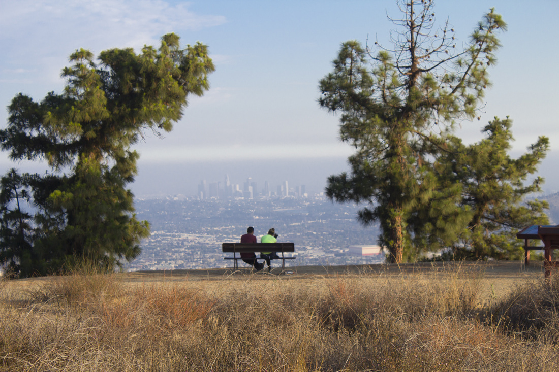
Perhaps one of the toughest hikes in the San Fernando Valley is the one that can be seen from just about anywhere in the Valley.   It's distinctive bleached white path climbs in a near perfect straight line to the sky on the border between  Burbank and Glendale, taunting any would-be challengers to make the ascent.  After years of driving past this gleaming beacon, I took that challenge.  After it all, it was so close to home I could just zip up in the afternoon for some quick views of the Valley and be back down in time for dinner.  I had no idea what I was getting myself into.  Oh, I made it; I had no choice as the sun was setting, but even the relatively easy lower half had me huffing and puffing.  The upper firebreak section, however, was down right grueling, akin to stair climbing a downtown skyscraper, albeit one with stunning views.  As an avid hiker and runner, I was surprised at the extreme soreness in my glutes the following morning.  The hike is divided into two sections, a lower and an upper half separated by a plateau with benches for taking in the views.  Most of the hikers I encountered were content to make it to the plateau to watch the sun set before heading back down, but even this lower loop was a strong moderate hike.  The upper portion is a very strenuous out-and-back to the summit of Mt. Thom.  The descent was even trickier as I had to work at keeping my speed down on the slick, sand covered rock.  This is not a trail for beginners, and the views aren't any more impressive from the summit than they are from the lower plateau, so if views are what you are after with a good strong hike, the lower loop is probably sufficient.  But if you are a fitness nut looking to push your abilities, take the firebreak to the top.  The mountain practically dares you.

Directions to Trailhead

Brand Park Library
1601 West Mountain Street
Glendale, CA  91201

Exit the 134 at San Fernando Road and head north/northwest for .7 mile.  Turn right onto Grandview Ave and proceed for 1.3 miles.  When you reach W Mountain Street, the park entrance will be directly in front of you. Drive to the end of the cul de sac.  As you make the left around the cul de sac, turn right onto the side driveway and into the parking area.

Trailhead is located in the picnic area behind the library, opposite the fire hydrant.  Rest rooms and water are available at the trailhead.

Mt. Thom Trail Guide
Click for printable .pdf map and guide.

Picture
Trailhead

        Trail begins in the picnic area behind the library directly opposite the 
        fire hydrant. There are several trails beginning at this point. Pick the 
        one moving uphill and to the left for approximately .03 mile.

Picture
Trail Junction 1

        The short segment you were on dead ends with a perpendicular trail. 
        Turn left and continue heading uphill for just under .2 mile.

Picture
Trail Junction 2

       From here to the overlook (halfway to the summit) the trail will divide
       and come together numerous times. It doesn't matter which you take 
       as they will all arrive at the same place. Vistas are better from the 
       lower trail, but if in doubt, stick to the wider, main trail.  Proceed around
       .4 mile to the next junction near the base of the overlook.

Picture
Trail Junction 3

       As you reach the base of the overlook, look for the trail to the left. This
       is a more gradual incline that will loop you around to the backside of 
       the overlook. If you prefer, you can take the very steep trail directly to 
       the overlook by continuing straight and heading for the trees.

Picture
Trail Junction 4

       At this fork, bear right and continue uphill .1 mile. 

       On your return, you will again bear right at this junction to return to the 
       parking area.

Picture
Trail Junction 5

        Make the sharp hairpin turn to the right and continue uphill .1 mile to 
        the overlook.  On the return trip, make the hairpin turn to the left.

Picture
Brand Library Park Overlook

          Great views and benches to rest weary feet. After you've taken in the
          views, loop back to pick up the long white trail you see heading to 
          the top of Mt. Thom.  This is the Firebreak Trail.

Picture
Trail Junction 6

        This begins the .7 mile, very steep and very slippery firebreak up to the
        Las Flores Motorway just below the summit of Mt. Thom. This 
        firebreak is mostly exposed rock with a thin layer of sand. Shoes with 
        good tread are mandatory.

Picture
Trail Junction 7

        The firebreak dead ends at the Las Flores Motorway.  Bear to your left 
        and continue uphill .2 mile to the Beaudry Motorways. Keep the 
        telephone pole at the junction in mind for your return trip. It marks the 
        top of the firebreak. If you miss it you'll continue walking downhill on   
        the Las Flores Motorway and end up very far from your car.

Picture
Trail Junction 8

        The Las Flores Motorway intersects with the Beaudry S and Beaudry 
        N Motorways and the access road to the antenna array on Mt. 
        Thom.  Excellent views of the Crescenta Valley and the San Gabriel 
        Mountains to the east and the San Fernando Valley to the west from 
        this intersection.

        Make a hairpin turn to the right and continue up the access road .05 
        mile to reach the summit of Mt. Thom. 

Picture
Summit, Mt. Thom, 2,440'

        Congratulations, you've made it to the summit of Mt. Thom.  The   
        access road ends at a gated area protecting the antenna array atop 
        Mt. Thom.  Do not enter the gated area.  Enjoy the views!

        If you look north, you will see a flat concrete structure about .1 mile 
        away.  This is a great place to sit and recuperate before beginning 
        your return trip.

       On your return trip from the summit, make the hairpin turn to your left 
       onto the Las Flores Motorway and continue downhill.

       Or, to continue to the concrete structure, proceed north on the Beaudry
       N Motorway for about 300 feet and make a hairpin turn to the left and 
       continue for another 50 feet.

       When you're ready to leave, make your way back down the Las Flores    
       Motorway to the Firebreak and continue down to the Brand Library 
       Overlook.  Returning down the Firebreak can be hazardous as the trail 
       is steep and the slick rock is covered in fine sand.  Use caution on your 
       descent.

Picture
Trail Junction 9

       Just before you reach the Brand Library Overlook, make the hairpin 
       turn to your right.

Picture
Trail Junction 10

        At the next junction take the hairpin turn to your left and continue 
       down to the loop trail.

Picture
Trail Junction 11

        On your ascent, you came up on the trail to your left.  For the descent,
        turn right and continue downhill for .15 mile keeping an eye out or the 
        next junction coming in on your left.

Picture
Trail Junction 12

        Watch for this junction on your left. It drops down pretty quickly and is 
        easy to miss if your not paying attention.  Follow the ridge down for 
        about .3 mile.

        If you miss this junction, the trail you're on will bring you back to the 
        parking area, but it has a very steep drop at the end and puts you in a 
        gated maintenance area for the city of Glendale. It's a pain. Make the
        turn.

Picture
Trail Junction 13

        Cross the pavement and continue downhill for about .1 mile. This 
        wooded area is meandering and crisscrossed with trails. Keep to the 
        larger path and keep moving downhill. It should bring you out at the
        top of the parking area by the forestry monument.

        If you get turned around, just keep moving downhill and to your left 
        and you'll come out near the library.

Picture
End of Trail

LIghtbox feature now active. Click on any trail photo for a larger version.
Picture
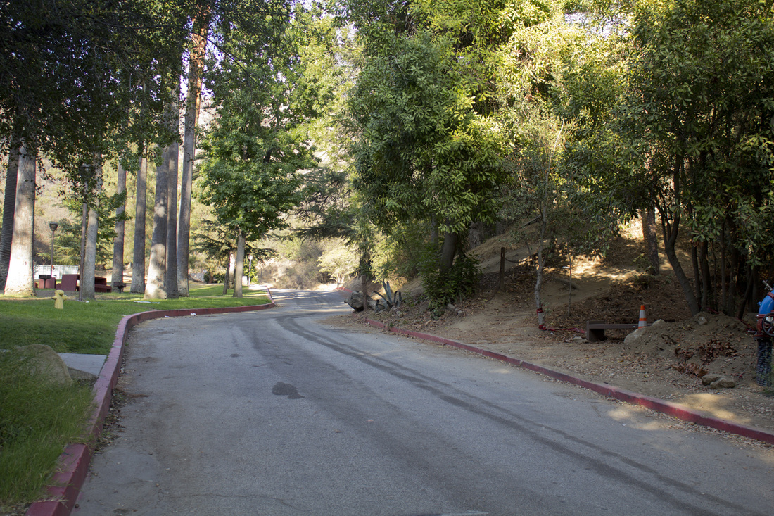
Trailhead located directly across from yellow fire hydrant
Picture
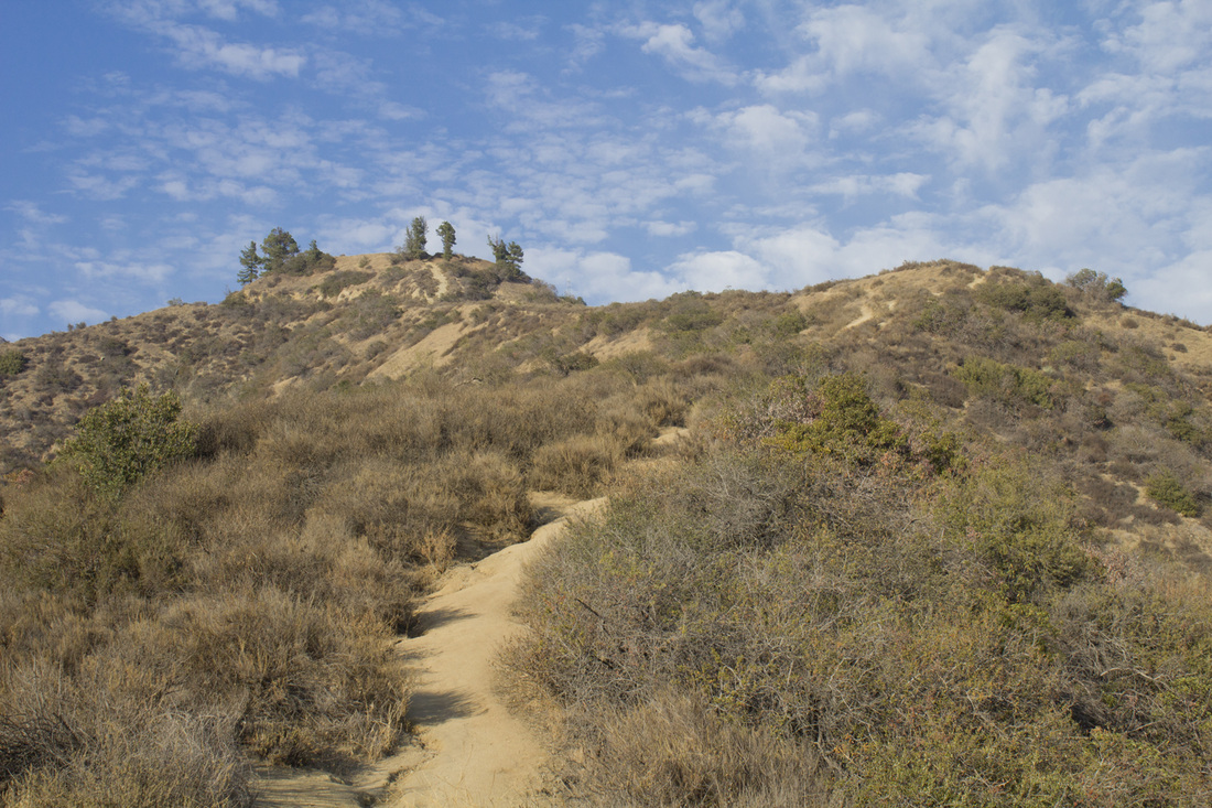
Single-track leading to the Brand Library Overlook
Picture
Brand Library Overlook
Picture
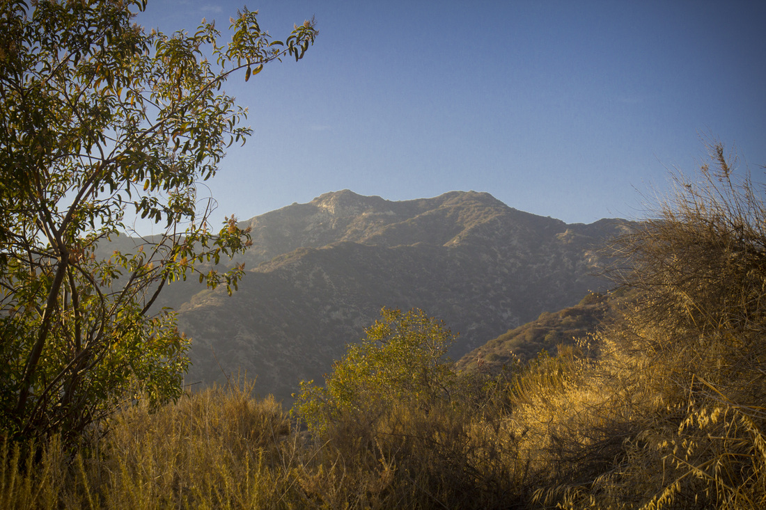
Verdugo Peak from the Mt. Thom Trail.
Picture
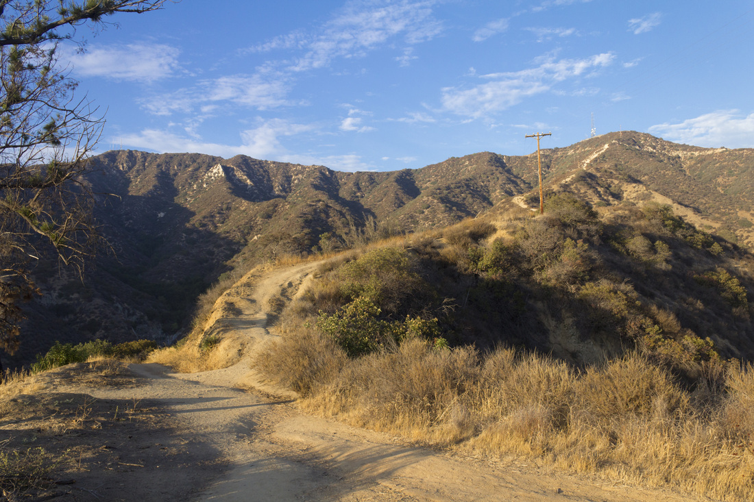
Firebreak Trail to Mt. Thom
Picture
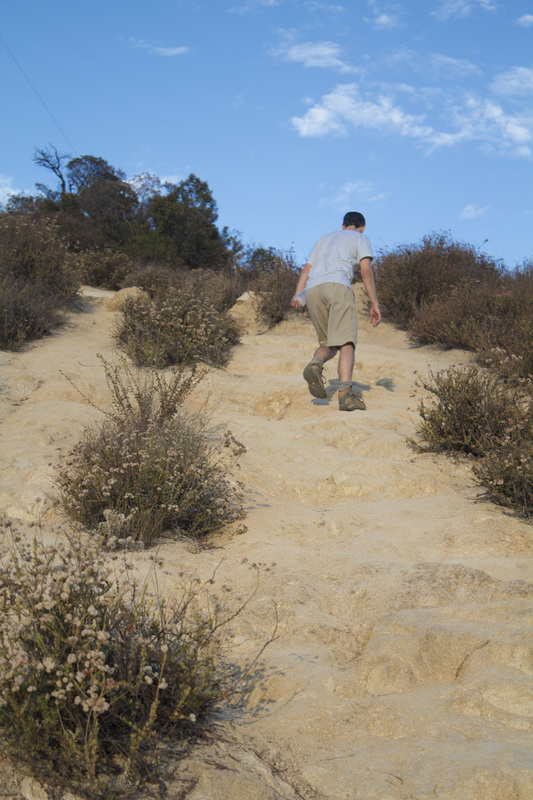
Climbing the Firebreak, It's Steep!
Picture
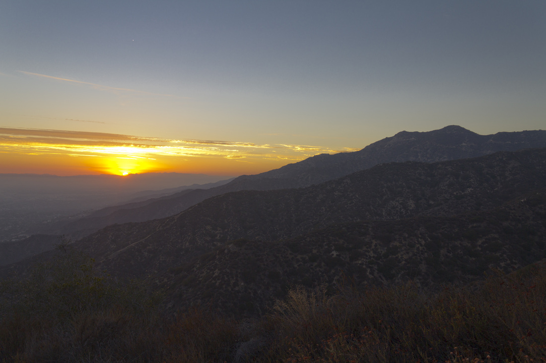
Sunset from Mt. Thom
Picture
Descending the Firebreak. Note the trail leading to the overlook in the background.
Powered by Create your own unique website with customizable templates.