
 | Martha Groves of the Los Angeles Times writes about the growing push to incorporate the Rim of the Valley Corridor into a National Recreation Area. You can read Ms Groves article using the link below. http://www.latimes.com/local/california/la-me-adv-rim-of-the-valley-20150524-story.html#page=1 |
|
0 Comments
We are sad to report the death of P-32, the mountain lion that crossed the 101 Freeway earlier this year. He was struck and killed by a motorist as he attempted to cross Interstate 5 near Castaic Lake in the early morning hours of Monday, August 10. P-32 and his sister P-33 made headlines in April when both cats made separate crossings of the 101. Big cats in the Santa Monica Mountains are hemmed in by highways and it makes it difficult for the animals to breed within a healthy gene pool. Because he was a juvenile, it is believed that P-32 was pushing further north to find a mate away from larger, more aggressive males. He had managed to cross not only the 101, but the 23, the 118 and the 126 highways before meeting his fate on the 5 in the Los Padres Mountains. The only other male puma to make it successfully out of the Santa Monica Mountains is P-22 who currently resides in Griffith Park after traversing both the 405 and 101 highways. P-22, however, is not considered a successful transfer by a Santa Monica puma as he is also hemmed in by highways with no female to mate with. For more information on this story, check out this article from KPCC's Sanden Totten.
 Franklin Lake, Franklin Canyon Park Franklin Lake, Franklin Canyon Park
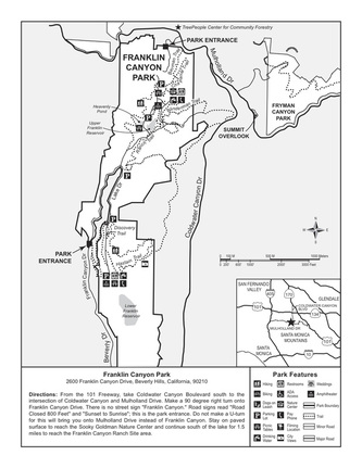
Nestled between Benedict and Coldwater Canyons on 605 acres of land is a hidden oasis of natural beauty: Franklin Canyon Park. This charming and idyllic spot offers a unique sense of seclusion that cannot be found at Tree People/Cold Water Canyon Park just a short distance away, or at the larger Griffith Park, overrun as it is with tourists scrambling to see the Hollywood Sign, hike to the Observatory or ride the Carousel. In fact, wandering the path around Franklin Lake or relaxing on the grassy field of Franklin Canyon Ranch, it is easy to forget that you are mere minutes from the hustle and bustle of Greater Metropolitan Los Angeles. That’s not to say there are no people in the park, it’s just that they seem to move at a slower, more relaxed pace. It also helps that there are fewer of them. This is due in part to the fact the park can be difficult to find if you don’t know where it is. No signage exists on the northern approach, and the southern entrance offers only one sign. As a result, parking is seldom a problem, even on weekends.
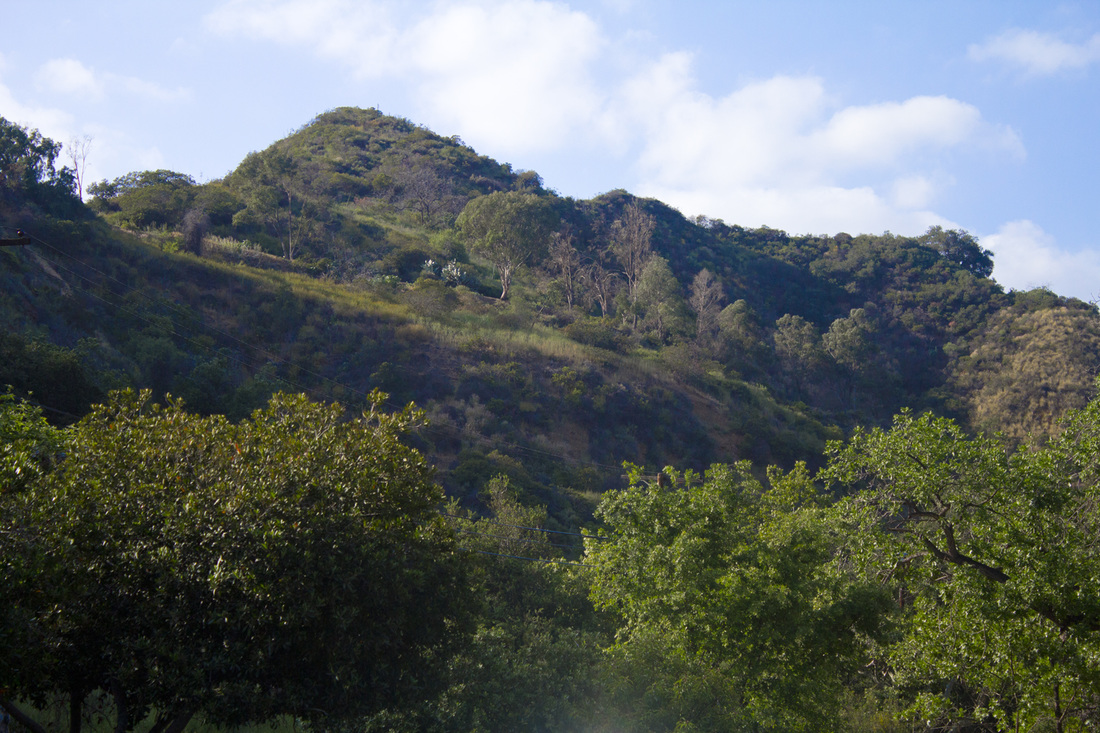
Skyline on Moonlight Hike
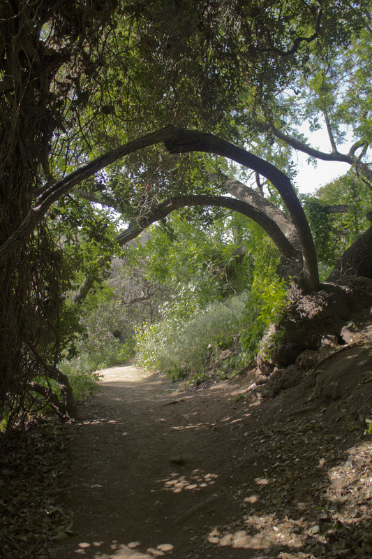
Hiking Franklin Canyon
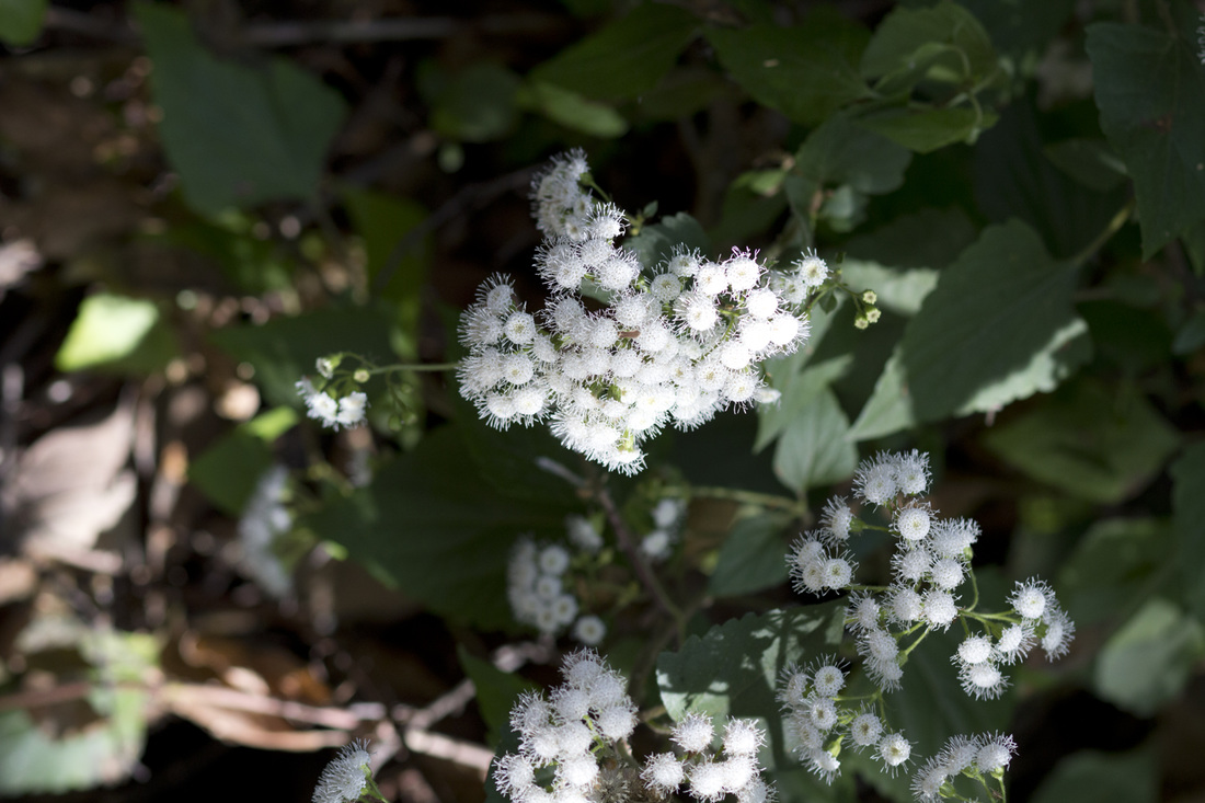
Flora and Fauna in the Canyon
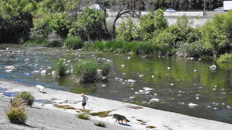
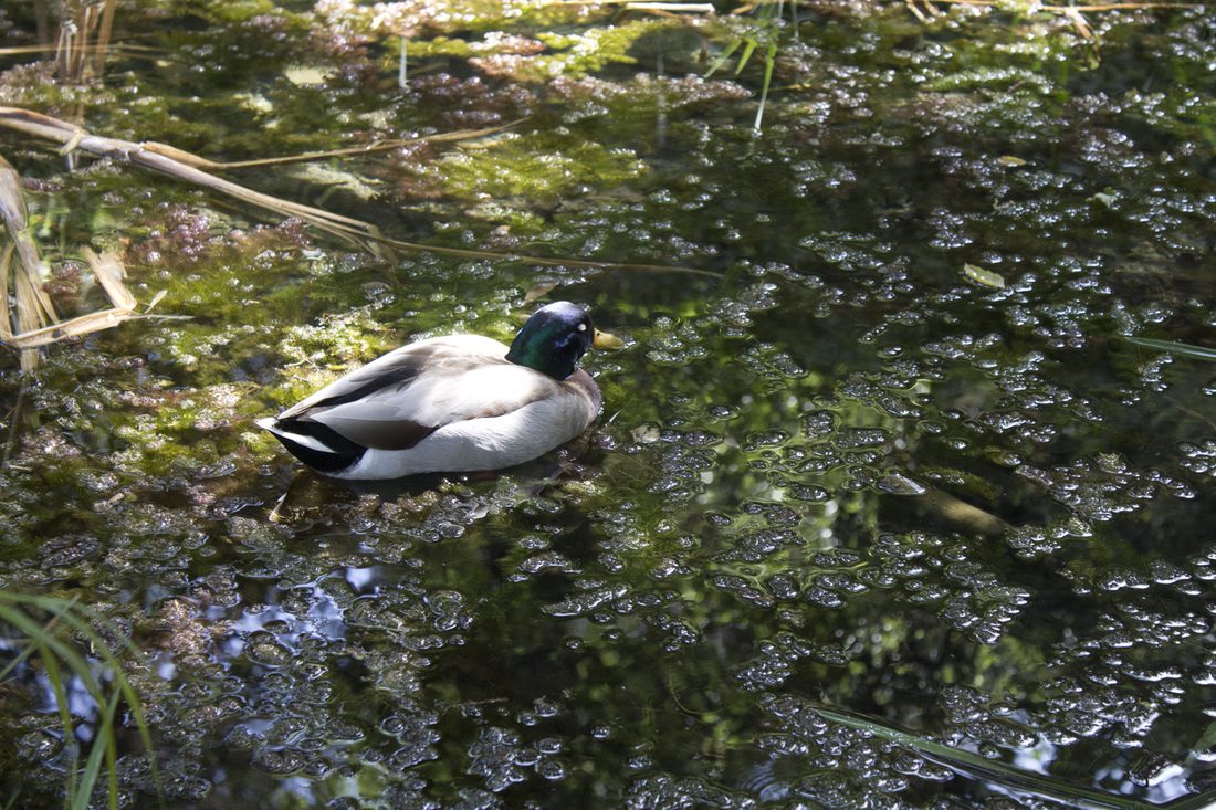
The bottom of the canyon is a rich, dense riparian landscape irrigated by a steady flow of water from Franklin Lake. Several underground springs also add to the watershed, creating a lush landscape year round. As you work your way up the slopes of the canyon, the canopy of oak, walnut and sycamore gives way to the more common chaparral of Southern California. The park is also a birdwatcher’s paradise being home to eagles, horned owls and seven different species of hawks. Franklin Lake and Heavenly Pond are nesting grounds for both Mandarin and Wood Ducks.
William Mulholland and the History of Franklin Canyon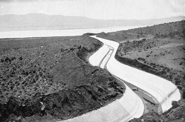 LA Aqueduct from Owens Valley LA Aqueduct from Owens Valley
Though not officially designated as parkland until 1981, the origins of the park as we know it today began in 1914. By the turn of the 20th Century, Los Angeles was already a thirsty town and Mayor Fred Eaton sought to quench that thirst by acquiring water rights from the Owens Valley to the east of the city. That these rights may not have been secured through strictly legal means remains a bitter controversy in many parts outside of the metropolitan area t this day. Whether legal or not, the rights were acquired and a 223-mile aqueduct was completed in 1913. The following year William Mulholland and the DWP (Department of Water and Power) began construction on two reservoirs in the upper reaches of the canyon to store and distribute water diverted from the Owens Valley. So much was water was diverted from Owens Valley by Mulholland’s aqueduct that farming became unsustainable by the early 20s and by 1926, just 13 years after the aqueduct opened, Owens Lake was completely dry.
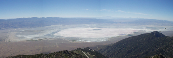
Owens Lake Today
Though the Owens Valley began to blow dust, Franklin Canyon, thanks to a steady supply of water from both the new reservoirs and a series of underground springs, began to bloom setting the stage for the unique ecological environment that exists today. But it wasn’t only Mulholland and the DWP that had a hand in shaping Franklin Canyon. Around the same time as Mulholland was constructing his reservoir, the family of oil magnate Edward L. Doheny purchased the land in the lower canyon for watering and grazing cattle. In 1935, the Doheny’s expanded their presence in the canyon by builing a modest Spanish Adobe style home as a summer retreat. The house still stands today as the Franklin Canyon Ranch and houses park personnel. So well before the US entered WWII, the basic building blocks of today’s park were already in place, and they remained untouched for nearly 40 years until the Sylmar Earthquake of 1971.
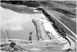 Embankment Failure, Lower Van Norman Dam Embankment Failure, Lower Van Norman Dam
The earthquake, measuring 6.7 on the Richter Scale, occurred at 6 A.M. on February 9 in the northeast corner of the San Fernando Valley. The massive trembler caused extensive damage throughout the valley including the near collapse of Lower Van Norman Dam. As a result, the city and the DWP began a system wide survey of its dams and reservoirs. The Franklin Canyon Reservoirs were deemed at high risk for failure. The lower reservoir was emptied completely and the upper reservoir level was lowered by 15’. A new, modern reservoir and surge dam were constructed below the Doheny Ranch as a replacement. With the upper reservoirs decommissioned and the Doheny Ranch properties slated for sale, the once protected Franklin Canyon was now open for development. Fortunately, Sooky Goldman, a political organizer and conservationist, had other plans. She had a vision for the canyon that included not only preserving the natural state of the canyon, but creating an education center that would enable inner city children to connect with California’s natural resources.
 Franklin Canyon from Hastain Trail Franklin Canyon from Hastain Trail
Enlisting the help of Congressman Howard Berman, Ms Goldman convinced the National Park Service to acquire the Doheny holdings as part of the Santa Monica Mountains National Recreation Area and the DWP to donate the upper reservoir property as parkland. The new Franklin Canyon Park, combining both properties, was opened to the public in 1981. Improvements to the property included the construction of the Sooky Goldman Nature Center, the William O. Douglas Outdoor Classroom and the Heavenly Pond. Activities at the park include native arts and crafts, photography and moonlight hikes and natural resources education, all presented free of charge. But man is not the only force working to restructure the park, nature is playing a hand as well. With the lowering of the water level in Franklin Lake (the former upper reservoir), grassy reeds have taken root on the northern perimeter of the lake, creating a marshy area that has become a waterfowl habitat. The reeds are currently encroaching on the southern end of the lake around the dam. As the grasses die off each season, the decaying vegetation is silting up the bottom of the lake. If this cycle continues unabated, the lake will eventually dry up and the ecology of the canyon will change once more, albeit to the more natural state that existed prior to the construction of the reservoir. The decision to be made will be whether to let nature take its course or let man preserve the idyllic oasis he inadvertently created.
For more information on Franklin Canyon Park and its scheduled activities, visit Franklin Canyon Park or Franklin Canyon NPS.
 The National Park Service Santa Monica Mountains Outdoors Guide, Spring 2015 edition, is now available to download either from Hike-LosAngeles' resource page or directly from the NPS site located here. The guide contains a complete list of hikes, bird watching, cultural events and other educational activities in the Santa Monica Mountains National Recreation Area for the months of April, May and June 2015. Many of these events are free and are sponsored not only by the NPS, but other local organizations such as the Audobon Society or the Sierra Club. Dates, locations, age appropriate guidelines are provide for each listing. For more information on the activities listed, simply contact the agency or persons listed for each event in the guide. So take a hike Los Angeles and discover the wilderness beyond your backyard!
|
Hike Los AngelesDedicated to discovering the wilderness beyond the pool area. Archives
April 2017
Categories
All
|


 RSS Feed
