Subscribe
HIKE LOS ANGELES
  • Home
  • Destinations
    • Griffith Park >
      • Mt. Hollywood
      • The Lonesome Pine
      • Bee Rock
      • Griffith Park Trail Run
      • Amir's Garden
      • Royce's Canyon
      • Hollywood Sign
      • Cahuenga Peak Hike
    • Santa Monica Mountains >
      • Escondido Canyon Hike
      • Inspiration Point Hike
      • Sandstone Peak Hike
      • The Grotto Hike
      • Calabasas Peak Hike
      • Paramount Ranch Hike
      • Fanklin Canyon Lake Loop Hike
    • San Gabriel Mtns./Angeles National Forest >
      • Sturtevant Falls Hike
      • Eaton Canyon Hike
      • Mt. Baldy Loop Hike
      • Echo Mountain Hike
      • Trail Canyon Waterfall Hike
      • Monrovia Canyon Waterfall Hike
      • San Gabriel Peak/Mt. Disappointment Hike
      • Mount Lowe Hike
      • Switzer Falls Hike
    • Verdugo Mountains >
      • Verdugo Peak
      • Mt. Thom Hike
      • Verdugo Sunset Hike
      • Cross of San Ysidro Sunrise Hike
    • Santa Susanna Mountains >
      • Oat Mountain Hike
      • Rocky Peak Hike
      • Don Mullally Trail Hike
      • Towsley View Loop Trail
  • Specialty Hikes
    • Sunrise/Sunset Hikes
    • Waterfall Hikes
    • Historic Hikes
    • Hollywood Sign
    • The 5 Peaks
  • Resources
  • Blog

   SLATE MAGAZINE'S
   BEST SWIMMING
   HOLES IN LA

       With summer approaching, now is the time to plan
       your visits to some of LA's best swimming holes with
​       Michael Juliano's list of best spots to beat the summer
       heat.

Los Angeles Swimming Holes

Thaddeus Lowe and the White City in the Sky

10/23/2014

3 Comments

 
Picture
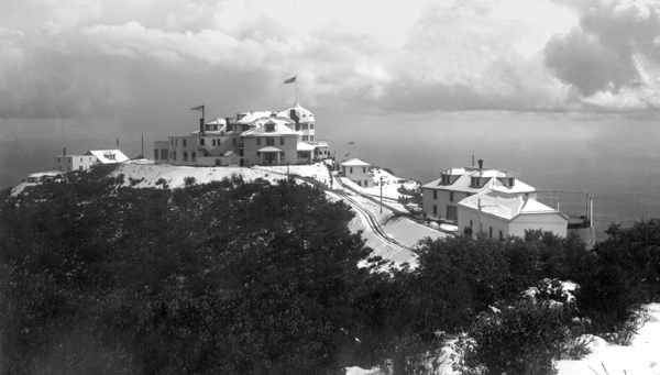
The White City, circa 1895
High on promontory above the town of Altadena, CA, there once was a dazzling Victorian resort known as The White City in the Sky. This ‘city’ was comprised of a 40-room chalet, astronomical observatory, zoo, dormitories, dance hall, bowling alley, tennis courts, picnic areas, machine shops and, the jewel of the city, the palatial 70-room Echo Mountain House. The entire complex of buildings was painted a brilliant white to reflect the southern California sun. Situated as it was at the tip of Echo Mountain, the resort could be seen glowing against the backdrop of the San Gabriel Mountains (then called the Sierra Madre Mountains) from downtown Los Angeles, some 13 miles distant. The resort was part of a series of hotels and taverns built to service the Mount Lowe Railway.

Picture
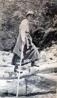
Thaddeus Lowe, circa 1865
The railway was the dream project of Professor Thaddeus Lowe and his engineer partner, David J Macpherson. At the time of the project’s undertaking, Professor Lowe had retired to southern California after having already lived a rather adventurous life. Entering this world in August of 1832, Lowe was one of five children born to Clovis and Alpha Lowe of Jefferson Mills, NH. Around the age of 10, Lowe’s mother passed away and his father remarried to Mary Randall and, by some estimates, sired another 7 children. Unable to support such a large brood, Lowe’s father boarded the young boy with a nearby farm. Unhappy with what was essentially an indentured servitude, Thaddeus ran away at the age of 14 to join his older brother in Boston where he began work as a shoe cutter.


While recovering from an illness at age 18, Lowe attended a travelling road show demonstrating the uses of lighter-than-air gases led by Professor Reginald Dinkelhoff. Fascinated by the science, Lowe joined the show as Dinkelhoff’s assistant and 2 years later bought the show when Dinkelhoff retired. Within five years, Lowe, using his knowledge of lighter-than-air gases, had become one of America’s premiere balloonists, creating a lucrative business giving balloon rides at state and county fairs. During one of his lecture-exhibitions, Lowe met a 19-year old Parisian actress, Leotine Agustine Gaschon. One week later on February 14, 1855, the pair were married. Over the course of their marriage Leotine would give her husband ten children, seven boys and three girls.

In 1859, Lowe constructed a massive 103-foot diameter balloon named the City of New York with the intent of making a transatlantic flight. The balloon, later renamed the Great Western, made several successful test flights, but before the transatlantic voyage could be undertaken, the American Civil War broke out. Two days after the state of Virginia seceded from the Union, Lowe attempted to reach the eastern seaboard from Cincinnati in the balloon Enterprise. Unfortunately for Lowe, the balloon went off course and he landed in Unionville, SC where he was promptly taken prisoner as a Yankee spy by Confederate forces. After some careful negotiation where Lowe pleaded his case as a man of science, the professor and his balloon were released. 

Picture
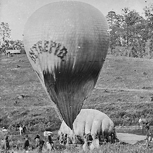
The Intrepid at the Battle of Fair Oaks, 1862
The incident opened up new possibilities for Lowe and in July of 1861, he offered to demonstrate the surveillance capabilities of his balloon for President Abraham Lincoln. Floating 500’ above the White House Lowe sent the first aerial dispatch by telegraph. Lincoln and his war department seized upon the idea of aerial surveillance and real-time troop movements relayed to commanders in the field. Lowe was given the go-ahead, and he flew in battle for the first time during the First Battle of Bull Run. So impressive was his flight that Lincoln ordered the formation of the Union Army Balloon Corps with Lowe named as Chief Aeronaut. Lowe would eventually command seven balloons with the corps, even launching them from a converted coal barge, effectively creating America’s first aircraft carrier. During his time with the Union Army, Lowe contracted malaria, an affliction that would bother him for the remainder of his life.
Following the war, Lowe moved to Norristown, PA. He continued experimenting with hydrogen and acquired 200 patents for his inventions. His most successful enterprise was a water gas process that generated large quantities of enriched hydrogen for heating and lighting, earning him a fortune in the process. In 1887, Lowe retired to Pasadena, CA with the hopes the dry climate would ease the lingering ailments from his bout with malaria. It was there he met the engineer David Macpherson. With Macpherson’s engineering skills and Lowe’s financial resources, the two hoped to create a rail line that would ride the crest of the San Gabriel Mountains to Mount Wilson. Unfortunately, the pair were unable to obtain all the necessary rights-of-way and so rerouted their planned railway to Oak Mountain (later named Mount Lowe) via the Echo Mountain promontory above Altadena.
The first section of rail began service on Independence Day of 1893. It ran from Lake and Calaveras in Altadena to Rubio Pavilion, a 12-room hotel at the entrance of Rubio Canyon. Passengers could then transfer to a funicular incline railway climbing the canyon to Echo Mountain. In 1894, the grand Echo Mountain House Victorian resort was opened, and in 1896, the final leg of the railway was completed to the Ye Alpine Tavern in Grand Canyon at the base of Mount Lowe. In all, there were nearly 7 miles of track.

The Echo Mountain house was a grand and stately structure capped with an imposing dome. A large porch for socializing ran along the front and two wings of the building, providing spectacular views of Pasadena, the San Gabriel Valley and even Catalina Island 65 miles away. The interior of the hotel was completed with natural wood and held a curio shop, a Western Union office, billiard room, shoeshine stand and barbershop among other amenities. To the left and right of the domed lobby were two wings of rooms for guests, while to the rear of the lobby was a formal dining room with views of Castle Canyon and Mount Lowe. Atop the incline railway powerhouse located in front of the resort, a 3-million candlepower searchlight had been installed that could be seen up to 50 miles at sea.  Lowe’s publicist, George Wharton James, took that a step further and claimed he could read his newspaper from the beam’s power shining through his window on Catalina Island. On the ridge behind Echo Mountain House was an astronomical observatory featuring a 16” telescope. Visitors could spend their days playing tennis, bowling, taking mule rides into the mountains or listening to their voices echo across Castle Canyon on several echophones installed along the rim of the canyon. At night there was a white-linen dinner service prepared on dishes etched with the resorts logo followed by dancing. The luxuriousness and sheer spectacle of the resort along with the incredible scenery quickly made the White City the top honeymoon destination in America. Unfortunately, the cost to construct and maintain the railway and the hotels proved to be too much for Lowe and the project fell into receivership. In 1899, only six years after it opened, the professor lost everything except for title to the observatory. But that was only the beginning of the end for the White City.
Picture
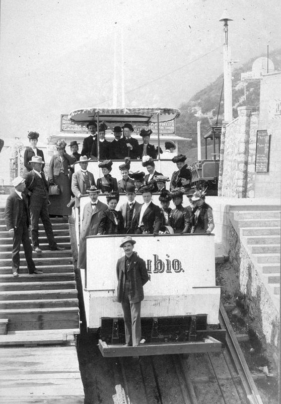
A funicular car, aka a White Chariot, at the summit
Picture
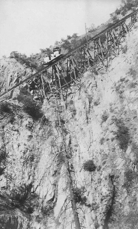
Mt. Lowe Incline Railway, circa 1895
Picture
Funicular car arriving at Echo Mountain House, circa 1895
Picture
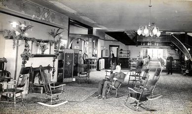
Interior Echo Mountain House, circa 1895
In 1900, a kitchen fire destroyed the Echo Mountain House, leaving only the foundation in its wake. The building had not been properly insured and thus was never rebuilt. In 1905, a second fire destroyed all the remaining buildings with the exception of the observatory. The incline railway powerhouse was rebuilt in 1906, but the rest of the property on Echo Mountain was left in ruins. In 1909, a flash flood destroyed the Rubio Pavilion hotel at the bottom of the funicular incline railway. The observatory held on until 1928 when a particularly strong Santa Ana wind blew the building down. The curator managed to escape moments before the collapse, taking the expensive telescope with him. Despite the catastrophes, the railway continued to operate under various owners, hauling passengers to the Mount Lowe Tavern (the renamed Ye Alpine Tavern) at Mount Lowe until 1936 when the tavern also succumbed to fire. The railway was now a line without a destination. As such, the railroad’s booster club organized one final excursion, and in December of 1937, the Mount Lowe Railway made its last public trek past the remains of the White City to the burnt ruins of the Mount Lowe Tavern. In March of the following year, a three-day thunderstorm washed the railroad itself from the mountain. What little remained of the buildings that once graced the promontory of Echo Mountain was declared a hazardous nuisance and blasted into history with dynamite by the US Forest Service between 1959 and 1962.
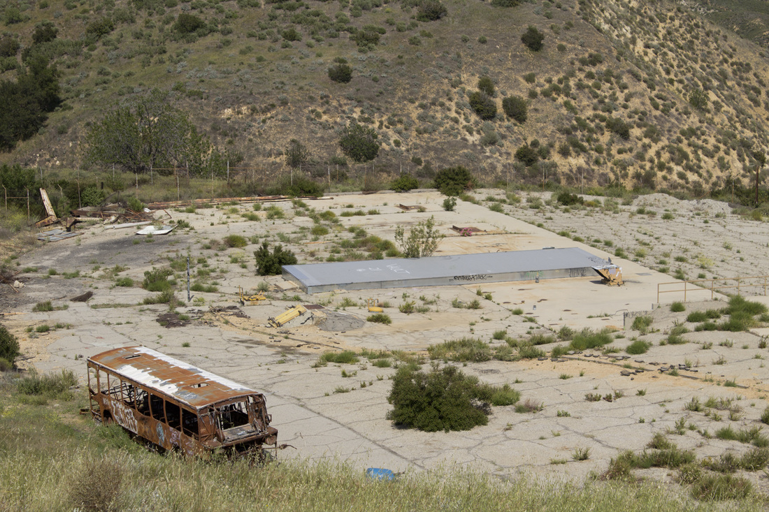
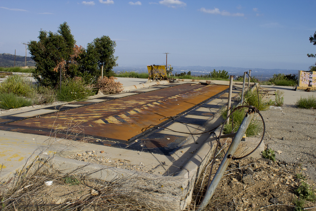
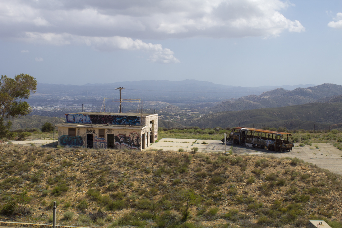
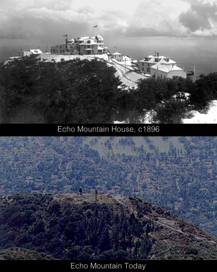
Echo Mountain Today

Today, all that remains of Professor Lowe’s dream are some foundations marking the location of the Echo Mountain House and it’s periphery buildings. The grip and guide wheels from the funicular powerhouse lay trailside, rusting in the bright California sun. On the rim of Castle Canyon, a replica echophone has been installed, allowing hikers to hear their voices reverberating across the canyon as tourists did more than 100 years ago.

The easiest way to reach the ruins of the White City is via the Sam Merrill Trail located at the intersection on Lake Avenue and East Loma Alta Drive in Altadena, CA. For trail details, click here.
3 Comments

Mount Rainier Hikers Feared Dead

6/1/2014

0 Comments

 
PictureMt. Rainier, Washington
Search helicopters have detected emergency locator beacons buried in the snow on Mount Rainer. Six climbers, two guides with four clients, were reported missing on Friday evening when they did not return as expected. The pings from the locators are registering in an area several thousand feet below the climber's last reported position. Park officials believe the expedition fell up to 3,300' in an avalanche prone area. Climbing gear was also spotted scattered across the section where the pings are coming from. Rescue and recovery efforts have been suspended at this time. Park Ranger Fawn Bauer told the AP News Service there was no viable chance of survival from such a fall. Falling rock and ice are currently preventing any recovery efforts. Bauer added, "In all honesty, we may never be able to get on the ground there." Names of the climbers are being withheld pending notification of the next of kin. More information can be found in this AP News story.

0 Comments

Hike Through History at Oat Mountain's LA-88 Missile Base

5/23/2014

4 Comments

 
Picture
Radiation Warning on Bunker Doors, LA-88 Oat Mountain
PictureLA-88 Radar Oat Mountain Summit, 1969
Hiking the wilderness areas surrounding Los Angeles provides intrepid trekers with sweeping mountain vistas, wildlife observation, quiet coves for personal reflection and a general escape from the hustle and bustle of big city living, though you may have to suffer through LA traffic in order to reach such nirvana. On occasion, you may also unexpectedly step into history. This recently occurred for me while making the climb up the wind swept grassy balds  of Oat Mountain. About halfway up the trail, the paved Browns Canyon Road, it passes through the remnants of an abandoned military facility constructed during the cold war, but with roots stretching back to World War II and the development of jet aircraft and nuclear weapons.

With the advent of jet fighters and bombers during the second world war, existing gun-based ant-aircraft batteries proved largely ineffective in combatting these new high speed, high altitude aircraft. In 1944, to counter this advance in weaponry, the US Army, in conjunction with Bell Laboratories, developed a line-of-sight anti-aircraft missile system called Project Nike (named after the Greek Goddess of Victory). The project’s goal was to acquire and track an incoming enemy plane should it evade Navy and Air Force resources and then launch and guide a defensive missile to the incoming target. This had never been attempted before and the complex Nike system required 3 separate yet integrated radar systems to achieve that result. Despite its promise, the system was largely considered a last ditch effort to prevent the enemy from delivering its payload as the initial effective range of the Nike Ajax missiles was only about 25 miles, but it marked the first time the US military attempted a strategic air defense of the country based on guided missiles, a safeguard that proactively sought out threats rather than one that simply threw up a barrage of projectiles hoping one would be lucky enough to intercept the target. The missiles later received an upgrade extending the range to about 100 miles and were given the designation Nike Hercules. Though the missiles were capable of carrying warheads of varying size in both conventional and nuclear explosives, the warheads on the US-based Nike missiles were almost entirely nuclear with an explosive rating of 20 Kilotons. By comparison, the bomb dropped over Hiroshima had an estimated explosive yield of only 16 KT.  Hiking the serene hills of Oat Mountain today, It is hard to imagine the fear and even paranoia that existed during the Cold War that would justify the detonation of a 20 KT nuclear weapon within 25 miles of Los Angeles, or any of the other 240 sites situated around the United States at the time for that matter, but it was the country's last line of defense for nearly 20 years. 

After a successful Nike test in November of 1951, the Army began deploy the system to defend strategic and tactical sites around the country. Sixteen such missile sites were established around Los Angeles to protect the city from Soviet attack beginning in 1956 and remained operational until the early 1970s. The Oat Mountain facility was part of this 'ring of defense' and was designated LA-88. Though LA-88 was closed in 1972, the site remained largely intact until a devastating wildfire swept through the area in 2008, destroying most of the buildings. What remains are mostly large concrete pads that once held barracks, mess halls and administrative offices and a large pad of pavement used as a basketball court. The launch area for the missiles is mostly bare, but the silo doors for the subterranean storage area for the missiles are still in place as is the substructure used to service the missiles.

PictureNIke Launch Pad Today
What makes LA-88 unique is that the trail to the summit of Oat Mountain passes directly through the heart of the former missile complex, providing great views of the facility’s remains.  Though it is illegal to trespass on the grounds themselves, the open gates have invited many a hiker and more than a few ‘taggers’ to take a look around. There are a few outbuildings still standing on the southern side of the trail, including the guard shack and missile assembly building. On the north side of the trail, the base flagpole can be found still standing tall in a small garden. In more recent years, the site has been used by the LAPD for SWAT training exercises as evidenced by the shot up buses on the premises. On a recent visit, it was noted that an access panel to the missile storage area beneath the silo doors was open and metal rungs descended into the dark depths below.  

In 2006, Howard Rathbun, who served at LA-88, returned to his former base for a stroll down memory lane. He has written an interesting article with before and after pictures comparing the base’s operational phase with its derelict state that can be found here. Mr. Rathbun was fortunate to visit before the 2008 fire and found all the buildings to be intact at that time. The black and white photos you see here are courtesy of Mr. Rathbun and the Nike Historical Society.

The hike to Oat Mountain’s summit is worth it just for the views and the grassy, rolling hills, but the chance to literally walk through history makes this hike all the more interesting. Another Nike site has been partially preserved in the Santa Monica Mountains at San Vicente Park. Self-guided displays give visitors a look into the Nike Program and how it was used around the country and the still standing radar tower provides impressive views across the Santa Monica Mountains, the San Fernando Valley and the Los Angeles basin.

Learn more about Project Nike here.

Picture
Radar Tracking, 1956
Picture
Missiles on the Launch Pad, 1956
Picture
Base Flagpole Today
Picture
Silo Doors Today
Picture
Missile Assembly Building Today
4 Comments

Puma 22 Develops Mange

5/10/2014

1 Comment

 
PicturePuma 22, one mangey cat
Puma 22 was captured recently after backcountry remote cameras snapped photos of the big cat that appeared to show the animal was suffering from the skin disease mange. Wildlife biologists confirmed P-22 had contracted the disease and his blood showed traces of toxins linked to rat poison. The cat appeared somewhat scraggly and was reportedly 10 pounds lighter than his last capture. While the effects of mange on mountain lions is not widely known, local bobcat populations that contract the disease can see their survival rate drop from 75% to around 30%. The biologists gave P-22 a large dose of selacmectin, a topical parasiteacide used to kill mites, fleas and ticks on domestic pets. The large cat was also given injections of Vitamin K to help combat the effects of the rat poison toxins. Though researches are concerned about P-22, his nocturnal behavior still seems to be normal and active. The cat has traveled throughout the park, ranging from Glendale Peak in the east to Cahuenga Peak in the west, preferring the hilly areas to the flatlands. His roaming has taken him out of the park as well. P-22 was recently caught on security cameras on Hollyridge Drive in the Hollywood Hills. View footage here.

1 Comment

Homeless Man Apparent Victim of Mountain Lion Attack

2/7/2014

0 Comments

 
A 50 year old homeless man was the apparent victim of a mountain lion attack last weekend in Perris, CA.  The unidentified man has been hospitalized since Saturday with severe lacerations and bites to the base of his skull and has been unable to communicate with investigators. He had been living in a makeshift camp near Navajo Drive and California 74 and was able to make his way to a nearby residence early Saturday morning for help.  Investigators from the California Department of Fish and Wildlife believe he may have been attacked as early as Friday.  Upon searching the campsite, it was determined the man was attacked as he slept in his sleeping bag.  Said Lt. Patrick Foy of the CDFW, "It was incredible that that amount of blood could accumulate in the sleeping bag and this guy could still be alive."

Baited traps were placed in the area, but attempts to capture the large cat have proved fruitless.  The attack comes right after recent sightings of a mountain lion were reported in the Verdugo Mountains of Burbank and Glendale.  California's last fatality from a mountain lion occurred in January 2004 in Orange county.  A Nevada County man was attacked in July 2012, but survived his injuries.  For more information on this story, read the LA Times article here or view the video below.
0 Comments

Mountain Lions in the Verdugo Mountains and Griffth Park

1/31/2014

1 Comment

 
One of the pleasures of hiking in a wilderness area is getting to see nature in action.  But when an area of urban sprawl like Los Angeles butts up against those wilderness area, nature sometimes comes to you.  And in a couple of recent incidents in Burbank, that nature comes with sharp claws and long teeth.  In the early morning hours of January 3, a mountain lion was spotted in the 1000 block of Hamline Place.  A local resident was alerted to big cat’s presence by his dogs.  When the man went to see what the ruckus was about the animal leapt over a fence and disappeared.  Later that night, a mountain lion was caught on a surveillance camera just a short distance to the north in Sun Valley, where a family's Boxer went missing. Both of these incidents followed another sighting from the week before in Glendale where a mountain lion, or puma, was seen dragging an 85-lb Labrador Retriever over a 3 ½ foot wall.  More recently, another sighting of a mountain lion occurred on January 29 near the 3000 block of Wedgewood Lane in Burbank.  While it is possible there could be more than on big cat on the prowl, all three sightings are well within the territorial range of a single cat, and the odds of multiple pumas crossing the 210 Freeway from the San Gabriel Mountains to the Verdugo Mountains at the same time are slim.  Still, a single mountain lion can cause panic in those not accustomed to seeing such large predators hanging out in their backyards.

Experts, however, say the animals pose little threat to humans, preferring to hunt smaller prey like raccoons or coyotes and, heartbreakingly for some, dogs and house cats.  Since 1890, there have only been 16 verified attacks on humans by mountain lions, six of which were fatal. 

Mountain Lion Safety Tips from
The California Department of
Fish and Game

 Do not feed deer; it is illegal in California and it will attract mountain lions. 
 Trim brush to reduce hiding places for mountain lions. 
 Do not allow pets outside when mountain lions are most active-dawn, dusk, and at night. 
 Bring pet food inside to avoid attracting raccoons, opossums, and other potential mountain lion prey. 
 Do not leave small children or pets outside unattended. 
 Install motion-sensitive lighting around the house. 
 Do not hike, bike, or jog alone. 
 Avoid hiking or jogging when mountain lions are most active-dawn, dusk, and at night. 
 Do not approach a mountain lion 
 If you encounter a mountain lion, do not run; instead, face the animal, make noise and try to look bigger by waving your arms; throw rocks or other objects. Pick up small children. 
 If attacked, fight back. 
 If a mountain lion attacks a person, immediately call 911. 

For additional information, please contact the Burbank Animal Shelter at 818-238-3340.

PicturePuma 22 in Griffith Park
As proof of their wariness of humans, biologists point to Griffith Park’s resident cougar, P-22, short for Puma 22. P-22, a young male mountain lion, entered the park in February of 2012 and has been living quietly on the north slopes above the Forest Lawn Cemetery and the Travel Town train museum.  While he has been photographed on National Park Service remote cameras, and more recently by National Geographic photographer Steve Winter, P-22 has remained elusive to the thousands of park visitors who tramp daily over his territory.  What makes his story so intriguing is not just that a mountain lion has taken up residence in an urban park within eyesight of Hollywood and downtown Los Angeles, but that he made it there to begin with.  DNA testing have shown that P-22 comes from the stock of cats residing in the Santa Monica Mountains and had to cross both the 405 and 101 highways to reach Griffith Park.

While there seems to be little risk to humans, authorities urge park visitors and local residents to take precautions to prevent antagonizing the cats or making them feel threatened.  The California Department of Fish and Game has prepared a list of safety tips (see side bar) to help mitigate attracting a mountain lion’s attention and what to do should one encounter a mountain lion in the wild, even if the wild comes to your backyard.

For more information on P-22 in Griffith Park, read this article from the Los Angeles Times:

Scientists Track Cougar's Wild Nightlife Above Hollywood

1 Comment

The Great Hiking Era

1/24/2014

2 Comments

 
Picture
Hiking and trekking into the wilderness for pleasure is a fairly recent human endeavor, though some still doubt pleasure can be found in huffing up a steep mountain incline or wading through ice cold streams while a blistering sun beats down on you from above.  In fact for most people prior to the start of the 20th Century, spending the day walking the perimeter of a canyon was absolute folly.  Wilderness areas had few, if any, roads or developed trails for recreational purposes.  What few existed were meant for more practical things like hunting and trapping.  Discovery of gold might bring a sudden influx of settlers, but the backcountry was still an area to be exploited, not enjoyed.

In the late 1800’s there was a shift in the way society perceived the wild lands beyond the growing urban sprawl of America’s cities.  This change was spurred in part by health concerns over the close quarters and polluted conditions in which many urbanites were forced to live.  The country offered clean water and fresh air for those able to afford the luxury—and healthful benefits—of leaving the cities for weeks at a time to enjoy the amenities of summer resorts that sprang up in New York’s Catskill Mountains or in the Poconos of Pennsylvania.  The San Gabriel Mountains of Southern California experienced a similar boon with the construction of private retreat cabins along the Santa Anita Wash and the Echo Mountain House resort accessible by the Mt. Lowe Railway.

The interest in turning to the woods for recreational opportunities was also heavily influenced by American naturalist John Muir.  Muir was a major advocate of wilderness preservation and is largely responsible for the preservation of Yosemite Valley as a national park.  
"Climb the mountains and get their good tidings. Nature's peace will flow into you as sunshine flows into trees."

                                   - John Muir
Picture
Referred to as the ‘Father of the National Parks’, Muir’s writings were read by millions, inspiring people from all walks of life to take a walk in the woods.  By the 1930’s, an estimated 2 million people a year visited the San Gabriel Mountains alone.

Los Angeles’ PBS affiliate, KCET, has put together a photo retrospective of this period of wilderness awakening and posted it on their website.  It’s a very informative and entertaining trip to a bygone era.  And the next time you complain about the lack of support in those new hiking boots, just think back to when hikes were done in long woolen skirts or vest and tie, and maybe that next couple of miles on the trail won’t seem so bad.

You can view KCET’s photos by clicking here.

2 Comments

Angeles National Forest Wildfire Near Glendora, CA

1/16/2014

0 Comments

 
PictureWildfire near Glendora, CA photo courtesy of Reuters
     A wildfire broke out in the Angeles National Forest just north of Glendora, CA  before dawn this morning.  As of this posting, 1700 acres had been consumed and several homes damaged.  There are unconfirmed reports of homes being destroyed, and photos of the area seem to verify these reports.  Residents in the vicinity of the fire are being evacuated.

     Southern California is experiencing a particularly dry winter and recent high winds are combining to create ideal fire conditions.  Under these conditions fires could break out anywhere and all area residents should trim shrubbery and remove dead or dry brush from their properties to help mitigate ignition sources and reduce chances of property damage in the event of a fire.  All hikers and outdoor enthusiasts should avoid the Glendora and surrounding areas due to heavy smoke and shifting wind conditions.  Once the fire is out, hikers should avoid the temptation to visit burn areas as the ground could be unstable.  Hiking in burn areas is also detrimental to the natural recovery of vegetation.  For more information on the fire follow this link: Colby Fire in Angeles National Forest near Glendora, CA

0 Comments

WELCOME TO HIKE-LOSANGELES.COM

1/11/2014

1 Comment

 
PictureSturtevant Falls
I was hiking in Eaton Canyon when I first had the idea of creating Hike-LosAngeles.com.  It seemed like a simple idea at the time: take a hike and then write a little about it.  Oh, if only it had stayed that simple, but by the time I returned home, that simple idea had become a bit more complex.  I began looking at other hiking sites and deciding what I did and didn’t like about them.  Most gave the basic essentials about the hikes, but many were assembled in a random, almost haphazard way.  The hikes were listed either alphabetically or in the order the hiker completed them.  Some of the larger, more ‘institutional’ sites were a bit sterile without any of the heart that makes a hike special.  Others were a bit too personal with my favorite being a hiker’s blog where the hiker found the sky so overwhelming he had to sit down on the trail and cry.  The description of his tears landing in the dust at his feet was a bit much and I can only imagine what his fellow hikers must have thought as they passed him weeping in the chaparral.

After reviewing a number of such sites I decided I would build the web destination that I would want to go to, one that would excite me about the trail and prepare me for whatever challenges I may encounter.  I also wanted to be able to find specific trails quickly and easily.  So my first goal was to organize the site in a way locate different types of hikes depending on mood and inclination.  As such, you will find the hikes are broken down by destination and specialty.  Under Destinations, the hikes are grouped geographically, which makes it easy to find a hike near your location.  Currently, our destinations include Griffith Park, the Verdugo Mountains and the San Gabriel Mountains.  Upcoming destinations will include the Santa Monica Mountains, the Hollywood Hills and the Santa Susana Mountains.

If you are not particular about where you go, but rather what you want to see, our Specialty Hikes include Waterfalls, Sunrise/Sunset and Historic Hikes.  As more hikes are added I expect to add a Challenging category for those who want a more aggressive workout with their hike.  All of the hikes on Hike-LosAngeles.com can be found on the map at the bottom of our home page.  Click on the map icons to get a brief description of the hike.

Once your have found a hike your interested in, navigate to that hike’s page for trail statistics (length, elevation and time estimates), a video highlight tour and a map and trail guide.  Again, clicking on the map icons will bring up a brief description of trail junctions or interesting features as they correspond with the trail guide.  The map and trail guide can also be downloaded and printed for your use on the trail.  Directions to the trailhead and parking are included with every hike, as well as locations of nearby restrooms and water fountains.  We’ve also included pictures of the hike’s scenic views as well as photos of major trail junctions so you know what to look for out on the trail.

When searching for a hike, you will find that by clicking on Destinations instead of one of the drop down menus, you will be taken to a page giving you information on the Los Angeles area.  Likewise, clicking on Griffith Park, rather than a specific hike in the park, will bring you to an informational page on the history of the park.  The same holds true for the Verdugo Mountains and the San Gabriel Mountains or any other destination on the site. 

Another good place for information is our resources page.  Here you will find local merchants who specialize in hiking gear, hiking groups and links to local, state and federal parks.  Initially, we are offering guides on 14 hikes on the eastern side of the metropolitan region, but we hope to add at least two new hikes a month beginning with some western walks in the Santa Monica Mountains.  And this blog will keep you up to date on interesting articles and facts about hiking in Los Angeles.  So there is plenty of exploring you can do right here on the website before heading out into the wilderness.  But once you do, drop us a line at info@hike-losangeles.com to tell us about your own outdoor adventures or maybe even recommend a hike to add to our growing collection.  So take a hike, Los Angeles, and become part of the scenery.


1 Comment
Forward>>

    Hike Los Angeles

    Dedicated to discovering the wilderness beyond the pool area.

    Archives

    April 2017
    May 2016
    August 2015
    May 2015
    April 2015
    March 2015
    October 2014
    June 2014
    May 2014
    February 2014
    January 2014

    Categories

    All
    Angeles National Forest
    Eaton Canyon
    Franklin Canyon
    Full Moon Hikes
    General Hiking
    Griffith Park
    Hike-LosAngeles.com
    History
    Los Angeles Hiking
    Mountian Lions
    Nike Missile Base
    Peak Bagging
    Puma 22
    San Gabriel Mountains
    Santa Monica Mountains
    Santa Susanna Mountains
    Stough Canyon
    Sturtevant Falls
    Verdugo Mountains

    RSS Feed

Powered by Create your own unique website with customizable templates.